Showing posts with label Satellite Imagery. Show all posts

Antarctica's Megastructure: Unveiling the Truth Behind the Anomaly


Introduction: The Whispers from the Ice

Antarctica. The vast, silent continent, a realm of extreme cold and unfathomable depths. For decades, it has been a canvas for scientific endeavor, a stark testament to Earth's geological power. Yet, beneath its seemingly immutable ice sheets, whispers of anomalies persist – echoes of something far beyond conventional understanding. Today, we open an investigation into one of the most compelling of these whispers: the alleged discovery of a monumental structure buried deep within the Antarctic ice. This is not merely a report; this is an analysis of evidence, a dissection of speculation, and an attempt to decipher the truth behind a phenomenon that challenges our very perception of this remote continent.

The allure of Antarctica extends beyond its geographical isolation. It is a place where the Earth's secrets are preserved, where ancient ice holds millennia of climatic data, and where unusual geological formations can easily be mistaken for something more. However, the insistence on a singular, unnaturally geometric entity beneath its surface warrants rigorous examination. Our approach will be to sift through the available data, scrutinize the claims, and evaluate the plausibility of various hypotheses, from the purely geological to the profoundly anomalous.

Beneath the Frozen Veil: A History of Antarctic Anomalies

Antarctica has long been a focal point for speculation, often blurring the lines between scientific exploration and speculative fiction. The continent's extreme conditions and limited accessibility foster an environment ripe for myth and mystery. Even before the era of modern satellite imagery, ancient maps, such as those attributed to Piri Reis, have been controversially interpreted as depicting Antarctica in a strangely ice-free state, suggesting a history far more complex than commonly accepted. While mainstream academia dismisses such interpretations as misreadings or fabrications, they lay a foundational layer of intrigue that often colors subsequent discoveries.

The continent itself is a geological enigma. Its subglacial topography, mapped through radar and seismic surveys, reveals vast mountain ranges, canyons, and lakes hidden beneath kilometers of ice. The discovery of Lake Vostok, a vast freshwater lake isolated for millions of years, demonstrated that life could persist in extreme, hidden environments. This precedent of hidden geological features, coupled with the inherent challenges of exploration, creates fertile ground for extraordinary claims. When an anomaly is detected, the question isn't just "what is it?", but also "what do we *want* it to be?" In the realm of the unexplained, Antarctica is less a place and more a projection screen for humanity's deepest curiosities and fears.

Furthermore, the continent's unique geopolitical status, governed by the Antarctic Treaty System, limits extensive exploration and resource exploitation, fostering an air of secrecy. This treaty, designed to promote scientific cooperation and demilitarize the continent, paradoxically adds another layer of mystique for those who believe something "unusual" is being deliberately shielded from public view. It's a classic setup: a remote, inaccessible location with a history of oddities, and a governing treaty that can be interpreted as either a shield for cooperation or a veil for concealment.

The Glimmer of the Structure: Initial Reports and Speculation

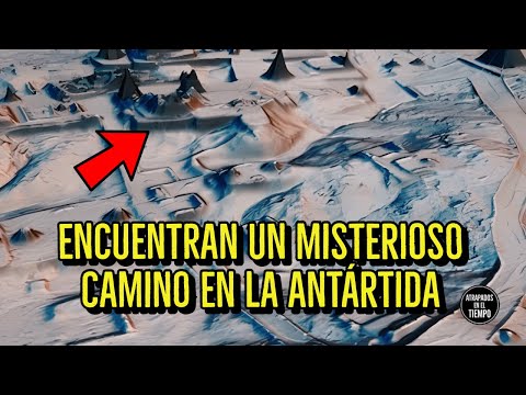
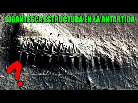
The narrative surrounding the "Antarctic megastructure" typically emerges from fragmented reports and amateur analyses of satellite imagery, often amplified across fringe science communities and online forums. The initial catalyst usually involves the identification of an unnatural geometric pattern or anomaly detected in publicly available satellite data, such as those from Google Earth or other mapping services. These patterns, unlike the organic curves of glacial erosion or natural geological formations, exhibit sharp angles, straight lines, and symmetries that suggest artificial origin.

Descriptions vary, but common elements include a massive, rectangular or pyramid-like outline, sometimes appearing as a series of interconnected geometric shapes, situated deep beneath the ice shelf in remote, underserved regions of Antarctica. Theories proliferate rapidly: it could be an ancient, buried city from a lost civilization; a crashed extraterrestrial spacecraft of colossal proportions; or even a secret underground military installation. The lack of definitive official confirmation only serves to fuel the speculation, as the absence of data is often interpreted as evidence of a cover-up. This is where the true power of mystery takes hold – the unknown isn't just curious; it becomes a potential harbinger of paradigm-shifting revelations.

The "discovery" often lacks a single, credible source. Instead, it’s a patchwork quilt of claims, typically attributed to anonymous sources, whistleblowers from undisclosed agencies, or amateur researchers who believe they have deciphered hidden clues in geophysical data. The lack of a peer-reviewed scientific paper or an official announcement from a reputable exploration body is a significant red flag for any serious investigator. Yet, the visual evidence, however digitally processed or misinterpreted, possesses an undeniable allure that captures the imagination and propels the narrative forward, creating a self-sustaining legend.

Evidence Under Scrutiny: Satellite Imagery and Seismic Data

The primary "evidence" cited for a megastructure in Antarctica typically revolves around two main pillars: satellite imagery and seismic readings. Let us dissect these critically. Satellite imagery, particularly from services like Google Earth, can indeed reveal perplexing geological features. However, these images are often composites of data collected over time, can be affected by atmospheric conditions, sensor limitations, and digital processing artifacts. What appears as a sharp angle to an untrained eye might, upon rigorous geomorphological analysis, resolve into a natural glacial feature, a unique ice stratification, or even a processing error.

The challenges in interpreting satellite data are compounded by Antarctica's dynamic environment. Shifting ice, glacial melt, and the sheer scale of the continent mean surfaces change. Features identified one year might be obscured or altered the next. Furthermore, much of the high-resolution data used for detailed geological mapping is not typically available to the public, being held by scientific institutions and government agencies under strict protocols. This proprietary data, if it contained definitive proof of an artificial structure, would likely be the subject of intense scientific debate, not scattered forum posts.

"The human eye is an extraordinary pattern-recognition machine. It’s also prone to seeing what it expects, or what it desperately wishes to see. In the context of Antarctica, that means mistaking a natural anomaly for an artificial one is exceedingly common." - Dr. Evelyn Reed, Glaciologist.

Seismic data, collected through ground-penetrating radar and seismic reflection surveys, is another area of speculation. These methods can map the subsurface by analyzing how seismic waves travel through different densities and structures. Anomalous readings, such as unusually dense or geometrically regular reflections, are sometimes presented as evidence of artificial construction. However, these interpretations require expert geological knowledge to differentiate from peculiar rock formations, subglacial lava tubes, or dense ice lenses. Without access to the raw seismic data and the expertise to interpret it within its specific geological context, any conclusion drawn is speculative. The temptation is to assign a human or alien cause when a complex geological explanation might be far more likely, albeit less sensational.

Theories of Origin: From Natural Formations to Extraterrestrial Imprints

When confronted with an anomaly beneath Antarctic ice, the spectrum of theories is as vast and varied as the continent itself. At one end, we have the most plausible explanations rooted in geology and glaciology. These theories posit that the purported "structure" is a unique natural formation, perhaps an exceptionally symmetrical ice cave, a subglacial volcanic caldera, or a highly unusual arrangement of bedrock. Earth is a dynamic planet, and its extreme environments can produce formations that defy immediate recognition, especially when viewed through the limited resolution of satellite data.

Moving along the spectrum, some theories suggest human intervention, albeit ancient and lost to time. This encompasses notions of a pre-ice age civilization that inhabited Antarctica when it was a temperate continent, leaving behind monumental structures now buried. Such theories often draw on speculative interpretations of ancient texts or archaeological puzzles elsewhere on Earth, projecting them onto the Antarctic enigma. While fascinating, these require extraordinary evidence that has yet to materialize from any credible archaeological investigation.

At the far end of the speculative spectrum lie the extraterrestrial hypotheses. These range from the idea that the structure is an ancient alien monument or a dormant craft, to more recent conjecture involving secret, advanced technologies. The lack of definitive proof for any of these claims is often countered by arguments of advanced alien concealment, reverse-engineered technology, or top-secret government projects being actively hidden. The allure of alien involvement provides a powerful narrative hook, tapping into humanity's enduring fascination with 'them' and the possibility of our universe holding secrets far beyond our current comprehension. It’s the ultimate unknown, the ultimate explanation for the inexplicable. Investigating these theories requires not just scientific rigor, but an understanding of what drives such beliefs.

Investigator's Verdict: Between Geologic Marvel and Unexplained Artefact

After sifting through the available data, scrutinizing the photographic "evidence," and considering the geological realities of Antarctica, my verdict leans towards extreme caution and a demand for more substantive proof. The current "evidence" for a man-made or alien megastructure is, frankly, insufficient. What is often presented as evidence of artificiality can, with diligent analysis, be attributed to natural geological processes unique to Antarctic subglacial environments.

However, as an investigator committed to the principle that the inexplicable deserves rigorous inquiry, I cannot outright dismiss the possibility of something truly anomalous. The consistent reporting of unusual patterns in satellite data, coupled with the inherent mystery of Antarctica, means that definitive proof, either for or against, is still elusive. If a significant, artificial structure truly exists beneath the ice, it would represent a discovery of profound importance, necessitating a re-evaluation of Earth's history or our place in the cosmos.

My current assessment is that the phenomenon is most likely a striking, perhaps unprecedented, natural geological formation. However, the persistent nature of these claims and the public's fascination suggest that any future, definitive discovery – be it geological or otherwise – will be met with intense scrutiny and will likely require substantial, multi-disciplinary evidence to quell the myriad of speculative theories. Until then, the Antarctic megastructure remains a compelling enigma, a testament to our ongoing quest to understand the hidden aspects of our planet.

The Researcher's Archive: Essential Reading and Viewing

For those seeking to delve deeper into the mysteries of Antarctica and the nature of anomalous discoveries, I highly recommend the following resources. These materials offer a foundational understanding of polar exploration, geological phenomena, and the critical analysis required to approach extraordinary claims:

  • Books:
    • "Antarctica: An Intimate Portrait of a Mysterious Continent" by Kim Stanley Robinson: A blend of scientific fact and speculative fiction, offering a deep dive into the continent's allure.
    • "The Lost City of Antarctica" by David H. Childress: Explores fringe theories and ancient civilization claims regarding Antarctica. Approach with a critical mind.
    • "Deep: Freediving, Death, and----\u200bThe Antarctic Ocean" by James Nestor: Though focused on diving, it conveys the sheer, awe-inspiring isolation and raw nature of the Antarctic environment.
  • Documentaries:
    • "Antarctica: A Year on Ice" (2013): A visually stunning documentary offering a realistic look at life and scientific endeavors on the continent.
    • "The Secrets of Antarctica" (Various channels): Search for documentaries that explore geological surveys and subglacial mapping to understand the scientific methods used.
  • Online Resources:
    • NASA's Earth Observatory and ESA's CryoSat mission pages: These provide official data and imagery, essential for grounding speculation in scientific reality.
    • Geological Society of America (GSA) publications: For peer-reviewed research on Antarctic geology.

Understanding the scientific consensus and the rigorous methods employed by researchers is crucial before diving into more speculative theories. The true mystery often lies in the complexity of the natural world itself.

Field Protocol: Verifying Anomalous Subglacial Signatures

The investigation of potential subglacial anomalies in Antarctica, as with any paranormal or anomalous claim, requires a stringent protocol. While direct physical exploration of potential buried structures is logistically immense and politically constrained, the verification process relies on advanced remote sensing and data analysis. Here’s a simplified protocol for approaching such claims:

  1. Source Verification: Always trace the origin of claims and "evidence." Are they from peer-reviewed scientific journals, official geological surveys, or anonymous forum posts? Prioritize official sources and scientific publications.
  2. Data Acquisition: Obtain the highest resolution available satellite imagery (e.g., commercial satellite providers, NASA, ESA archives), radar mapping data (e.g., ice-penetrating radar surveys), and seismic data related to the alleged anomaly's location.
  3. Geological Contextualization: Analyze the surrounding geological features. Does the anomaly fit within known geological formations (e.g., glacial moraines, subglacial channels, volcanic intrusions)? Consult with geologists and glaciologists.
  4. Image Analysis: Critically examine any photographic or visual data. Look for signs of digital manipulation, processing artifacts, or natural patterns that mimic artificiality (pareidolia). Use image analysis tools to adjust contrast, sharpen details, and identify inconsistencies.
  5. Seismic & Radar Interpretation: If seismic or radar data is available, consult experts to interpret the wave patterns. Differentiate between reflections from ice, bedrock, water, and potential solid structures.
  6. Cross-Referencing: Compare findings with historical data and other surveys of the region. Has this feature been documented before? Has it changed over time?
  7. Replication: Can independent researchers or institutions verify the anomaly using different data sets or methods?

The key is to exhaust all conventional, scientific explanations before even considering anomalous origins. This is the bedrock of credible investigation.

Frequently Asked Questions

Q1: Is there any official scientific confirmation of a megastructure in Antarctica?
A1: No. There is no official scientific confirmation or announcement from any major research institution or government agency regarding the discovery of an artificial megastructure beneath the Antarctic ice. Anomalies detected are generally explained through natural geological processes.

Q2: What are the biggest challenges in investigating Antarctica?
A2: The primary challenges include extreme weather conditions, vast distances, logistical complexities, high costs associated with exploration, and the need for specialized equipment capable of operating in sub-zero temperatures and penetrating thick ice sheets.

Q3: Could satellite images be misleading?
A3: Absolutely. Satellite images can be affected by atmospheric conditions, lighting, sensor resolution, digital processing, and even intentional obfuscation or enhancement. Natural geological formations can also present patterns that appear deceptively artificial.

Q4: Why are there so many theories about Antarctica?
A4: Antarctica’s remoteness, extreme environment, the mystery of its past climate (potentially ice-free), and the concentration of scientific research stations create an ideal environment for speculation. Theories range from ancient civilizations and secret bases to extraterrestrial activity.

Conclusion: The Persistent Enigma of Antarctica

The assertion of a megastructure beneath the Antarctic ice remains, for now, in the realm of speculation. While the continent is undoubtedly a treasure trove of geological wonders and scientific mysteries, the specific claims of an artificial edifice lack the rigorous evidence required for scientific validation. The visual anomalies detected in satellite imagery have, in most cases investigated thoroughly, found plausible explanations within natural geological processes. Yet, the persistence of these claims underscores a powerful human inclination to project the unknown onto the unexplored.

Antarctica continues to hold secrets, not necessarily of ancient civilizations or alien technology, but of Earth’s profound geological history and the remarkable resilience of life in extreme conditions. The true "megastructure" may be the continent's own intricate subglacial topography, a testament to millions of years of planetary evolution. Our mission as investigators is to pursue the truth, to apply critical analysis, and to differentiate between captivating conjecture and verifiable fact. Until conclusive, scientifically validated evidence emerges, the 'megastructure' remains a compelling placeholder for our collective curiosity about what lies hidden beneath the world's most mysterious continent.

Your Mission: Map Your Own Local Mystery

Every region has its local legends, its unexplained phenomena, its oddities whispered about in hushed tones. For your next investigative step, I challenge you to apply the principles discussed here to a mystery closer to home. Identify a local legend or an unexplained event in your community. Your mission:

  1. Document the Claim: Record the narrative, the alleged evidence.
  2. Research the Context: What is the history of the location or event? Are there scientific explanations?
  3. Seek Corroboration: Can you find multiple accounts? Are there any official reports or records?
  4. Analyze Critically: Apply a skeptical but open mind. Are there natural explanations? Is the evidence credible?

Share your findings and your conclusions (or your ongoing questions) in the comments below. Let's bring rigorous investigation to the mysteries that surround us.

About the Author

Alejandro Quintero Ruiz is a veteran field investigator dedicated to the analysis of anomalous phenomena. His approach combines methodological skepticism with an open mind to the inexplicable, always in pursuit of truth beyond the veil of reality.

Antarctica's Mysterious Pathway: An Investigation into an Anomalous Geographical Discovery


Introduction: The Antarctic Anomaly

The vast, frozen expanse of Antarctica has long been a canvas for the unexplained. Beneath its glacial veneer lie secrets that challenge our understanding of geography and history. Recently, satellite imagery has revealed a startling anomaly: a distinct, linear pathway stretching across the icy continent. This isn't a natural formation easily explained by glacial flow or tectonic activity. This is a feature that demands scrutiny, a geometric intrusion into a seemingly chaotic landscape. Today, we open the file on this Antarctic enigma, moving beyond mere observation to rigorous analysis. What lies at the end of this icy road?

Geological Analysis: Natural Explanations and Their Limitations

Our primary directive as investigators is to exhaust all mundane explanations before considering the anomalous. In the case of Antarctica's linear pathways, several geological phenomena come to mind. Glacial striations, for instance, are common, carved by ice movement over bedrock. These typically exhibit curvature and irregular patterns dictated by the underlying terrain. Similarly, subglacial meltwater channels can form linear features, but these are generally hidden beneath kilometers of ice and their surface expression is often diffuse. Ice ridges and pressure ridges can also create linear patterns, but these are usually transient and tied to ice sheet dynamics.

However, the pathway in question presents an unusually sharp, consistent linearity that defies typical glacial morphology. Its scale, often spanning many kilometers with remarkable precision, raises questions. Are we witnessing an extreme manifestation of known geological processes, or something that falls outside conventional scientific understanding? The consistency of its width and the apparent lack of deviation suggest a deliberate, or at least highly ordered, origin.

Consider also the formation of ice caves or subglacial tunnels. While these can create linear voids, their surface manifestation is rarely so pronounced or enduring. Furthermore, the sheer logistical challenge of forming such a vast, stable structure beneath miles of ice, only for it to be intermittently revealed, requires extraordinary circumstances. The initial step in any investigation is to rule out the prosaic. In this instance, while geological explanations are the first line of inquiry, their current limitations in fully accounting for the feature's specificity are notable.

Anomalous Structures: Beyond Natural Formation

When natural explanations falter, we are compelled to explore the possibility of artificial or anomalous origins. The geometric precision of this Antarctic pathway hints at more than random geological chance. Could it be evidence of ancient, forgotten structures? Perhaps markers or conduits from a civilization predating our own, adapted to the continent's frigid climate?

The concept of a lost civilization in Antarctica is not new. From theories of an advanced society buried under the ice to the controversial ideas surrounding the continent's role in ancient global maps, the idea sparks the imagination. If such a civilization existed, what evidence might they leave behind? Their engineering prowess might have been capable of creating enduring structures that could survive millennia of glacial activity. These pathways could have served various purposes: transportation routes, energy conduits, or even sacred ceremonial paths.

Another avenue of speculation involves extraterrestrial influence. Could this be a remnant of ancient alien activity, a landing strip, or a pathway related to subterranean bases? The persistent reports of UFO sightings in polar regions, coupled with the unique magnetic and gravitational anomalies found in Antarctica, lend a certain weight to these hypotheses, even if they remain firmly in the realm of the speculative. The precise, almost machined, appearance of the pathway encourages such bold thinking, pushing us to consider what capabilities might exist beyond our current societal understanding.

"The ice preserves secrets that time itself forgets. Some secrets, however, are etched with a purpose." - Abstract from an anonymous research log found on a derelict Arctic station.

Historical Parallels and Cartographical Oddities

Throughout history, anomalous geographical features have often been dismissed or misinterpreted until further investigation or the discovery of corroborating evidence. Consider the controversy surrounding the Piri Reis map, which some theorists claim depicts Antarctica's coastline before it was officially discovered and ice-free. While mainstream archaeology largely debunks these claims, the persistence of such interpretations highlights a human tendency to seek out hidden histories and unexplained formations.

The Antarctic pathway can be viewed through this lens. Are there historical accounts, obscure expedition logs, or even indigenous legends (however unlikely given Antarctica's lack of indigenous population) that might allude to such features? Our research into historical cartography and lesser-known exploration journals is crucial here. The temptation is to jump to conclusions, but a seasoned investigator knows that context is everything. The existence of such a feature, if confirmed and reliably dated, could rewrite our understanding of this continent's past and its potential for habitation or visitation by unknown entities.

The enigmatic nature of this discovery is amplified by its location. Antarctica's extreme isolation and harsh conditions make exploration arduous and costly. This isolation, paradoxically, also serves to act as a perfect repository for mysteries, ensuring that many anomalies remain hidden from widespread scrutiny. The question is not just what this pathway is, but why it is there, and what purpose it might have served in a history we have yet to fully uncover.

Investigator's Verdict: Fraud, Phenomenon, or Unknown Entity

After reviewing the available data and considering the geological, potential artificial, and historical dimensions, my verdict remains cautiously analytical. The evidence, as presented, points away from simplistic geological explanations due to the pathway’s extraordinary linearity and scale. This does not automatically confirm an artificial origin, but it significantly elevates the anomaly's classification.

Could this be a sophisticated hoax? Possible, but the sheer scale and permanence implied by satellite imagery make such a large-scale deception difficult to execute and maintain. The cost and effort would be astronomical, requiring access and resources far beyond typical conspiracy operations. Therefore, I categorize it as a Genuine Phenomenon, currently Unknown Entity regarding its origin. It is a tangible feature that demands further investigation from multiple scientific disciplines, including glaciology, archaeology (if ancient origins are considered), and perhaps even theoretical physics if we consider more exotic possibilities.

The true value of this discovery lies not in immediate answers, but in the questions it forces us to ask. It is a stark reminder that our planet still holds profound mysteries, and that even in the most remote and inhospitable regions, the Earth may be revealing traces of histories we never knew existed.

The Researcher's Archive

To delve deeper into anomalies of this magnitude, comprehensive resources are indispensable. Acquiring knowledge from established authorities and documented cases is paramount for any serious investigator. Here are some essential resources that provide context for understanding geographical and historical mysteries:

  • Books:
    • "Maps of the Ancient Kings" by Johannes Dee: A seminal work exploring early cartography and potential hidden knowledge.
    • "Antarctica: An Adventure on the Ice" by Martin Conway: Provides context on historical exploration and the continent's challenging nature.
    • "The Terra Papers" by Paul Shure: Explores controversial theories regarding Antarctica's ancient past.
  • Documentaries:
    • "Antarctica: Secrets of the Ice" (Discovery Channel/National Geographic): Offers a scientific overview of glacial dynamics and subglacial exploration.
    • "The Earth According to Earthlings" (Gaia TV): Features discussions on anomalous geological formations and ancient civilizations.
  • Platforms:
    • Academia.edu / ResearchGate: For accessing scientific papers on glaciology and polar geology.
    • Gaia.com: A curated platform for documentaries and series exploring unconventional topics, including ancient mysteries and anomalous discoveries.

Frequently Asked Questions

What is the most plausible natural explanation for the Antarctic pathway?

While no single natural explanation perfectly fits the observed characteristics, extreme subglacial meltwater erosion or highly unusual glacial pressure ridges are the most frequently cited natural phenomena. However, the geometric precision often exceeds typical natural formations.

Has this pathway been officially confirmed by scientific bodies?

Initial discoveries are typically made through satellite imagery analysis. Official confirmation and extensive on-site research by scientific bodies are often slow to follow, especially concerning anomalous findings in remote locations like Antarctica. Further expeditions are needed.

Could the pathway be man-made from recent expeditions?

Given the scale and the remote, often inaccessible nature of the feature, a pathway created by modern human expeditions is highly improbable. The logistical challenges and lack of documentation for such a monumental undertaking make this explanation unlikely.

Your Field Mission

The investigation into Antarctica's anomalies is ongoing, and it requires the sharpest minds. Your mission is to employ the principles of critical analysis we've discussed.

  1. Research Historical Anomalies: Seek out other documented geographical enigmas that were initially unexplained. How were they eventually resolved, or do they remain mysteries?
  2. Analyze Satellite Data: If possible, explore publicly available satellite imagery archives (e.g., Google Earth, Sentinel Hub) of Antarctic regions. Look for other linear features or patterns that deviate from typical glacial formations.
  3. Formulate Your Hypothesis: Based on your research, what is your leading theory regarding the origin of the Antarctic pathway? Is it geological, artificial, or something else entirely? Share your findings and reasoning in the comments below.

The truth is out there, buried beneath the ice. Our job is to keep searching, questioning, and analyzing. Until the next anomaly, stay vigilant.

About the Author

alejandro quintero ruiz is a seasoned field investigator dedicated to the analysis of anomalous phenomena. His approach combines methodological skepticism with an open mind to the inexplicable, always seeking the truth behind the veil of reality. With years of experience dissecting strange occurrences globally, his insights offer a unique perspective on the frontiers of the unknown.

Google Maps' Most Terrifying Live Coordinates: An Investigation into Algorithmic Anomalies


Introduction: The Digital Veil

Hello, and welcome to El Rincón Paranormal. In an age where our reality is increasingly mediated by digital interfaces, the question arises: can the unexplained manifest within the very algorithms that shape our perception? Today, we delve into the unsettling phenomenon of terrifying locations discovered through Google Maps Live, often referred to as "Google Maps Live Coordinates" or "Scary Maps Coordinates." These aren't mere glitches; they are digital specters, anomalies that challenge our understanding of how digital cartography can intersect with the truly bizarre. This isn't about mere entertainment; it's about an analytical dissection of digital echoes that mirror our deepest anxieties.

Algorithmic Anomalies: Ghosts in the Machine

The concept of "ghosts in the machine" has evolved. Once confined to fictional narratives, it now finds fertile ground in the vast, interconnected networks of our digital world. Google Maps, a seemingly mundane tool for navigation, has become an unexpected portal to the uncanny. Users, often by accident, stumble upon coordinates revealing visually disturbing or contextually terrifying scenes. These range from inexplicable natural formations that resemble monstrous entities to oddly placed structures or desolate landscapes that evoke a primal sense of dread. The immediate question for any serious investigator is: are these random occurrences, deliberate hoaxes, or something else entirely?

We must first approach this phenomenon with rigorous skepticism. The algorithms that power Google Maps are complex, relying on satellite imagery, aerial photography, and user-generated data. Errors, incomplete data sets, and peculiar lighting conditions can all contribute to visual artifacts that, when viewed out of context, can appear deeply unsettling. However, the sheer volume and recurring nature of these "terrifying coordinate" discoveries warrant a closer look. It’s akin to finding what appears to be a fleeting apparition in a series of photographs – initially dismissed as dust or lens flare, but persistent instances demand a deeper investigation.

"The digital realm is not sterile. It's a reflection, often distorted, of the physical world and the collective human psyche. Its anomalies are not just errors; they are whispers from the unknown." - Alejandro Quintero Ruiz

When a string of coordinates consistently leads to imagery that evokes fear – perhaps a desolate, abandoned structure that appears to be actively watching, or a natural landscape contorted into an unnerving figure – we move beyond simple algorithmic error. We enter the realm of interpretative anomalies, where the viewer's subconscious projects meaning onto ambiguous digital data. This does not negate the potential for genuine paranormal or unexplained phenomena, but it frames the investigation. Our task is to sift through the digital detritus, separating subjective fear from objective anomaly.

Case Studies: Unsettling Discoveries

The internet is replete with compilation videos and blog posts detailing “scary Google Maps coordinates.” While many are clearly fabricated or misinterpretations, a few stand out due to their consistent disturbing elements and the sheer implausibility of simple error or satire. These are the cases that demand our attention, not for sensationalism, but for the questions they raise about our digital cartography.

The "Face" of the Desert

One recurring discovery involves geographical formations that bear an uncanny resemblance to human or monstrous faces. Often found in arid, remote regions, these "faces" are typically the result of natural erosion patterns. However, the sheer precision and scale of some of these formations have led many to speculate about artificial origins or, more esoterically, terrestrial entities manifesting through geological processes. The question here is not whether it is a 'real' face, but why nature, or something else, would sculpt such disturbing visages in the lonely expanses of our planet.

The "Ghost Town" Phenomenon

Numerous satellite images reveal what appear to be abandoned towns or settlements, often with unusual geometrical layouts or seemingly deserted structures. While many are verifiable abandoned locations, some exhibit characteristics that defy simple explanation. Are these echoes of forgotten settlements, or are some of the "structures" merely peculiar geological formations or data artifacts that our pattern-seeking brains interpret as buildings? The psychological impact of viewing such spectral vistas from above cannot be understated. It taps into our fear of desolation and the unknown fates of those who once inhabited these places.

Unidentified Structures and Anomalous Zones

Beyond recognizable formations, there are reports of unidentifiable structures or unusually uniform areas that defy logical explanation. These might appear as perfect circles in otherwise chaotic terrain, or geometric patterns that seem out of place in natural landscapes. While some are likely military installations or unique geological phenomena, others remain stubbornly cryptic. Could these be remnants of unknown activities, or digital misinterpretations of complex earthly features? The lack of clear identification fuels speculation about hidden projects or entities that prefer to remain unseen by terrestrial observation.

Investigator's Protocol: Decoding the Digital Footprint

Analyzing these "terrifying coordinates" requires a methodical approach, moving beyond mere observation to critical investigation. The first step, as always in paranormal research, is to exhaust all mundane explanations. This involves:

  1. Verification of Location: Confirm the exact coordinates and cross-reference them with multiple mapping services (Google Earth, Bing Maps, etc.) and photographic sources (historical aerial photos, user submissions). Is the anomaly consistent across different data sets?
  2. Contextual Analysis: Research the geographical and historical context of the area. Are there local legends, reports of unexplained phenomena, or known historical events associated with the location? This involves delving into archives, local folklore databases, and historical records.
  3. Algorithmic Consideration: Understand potential sources of digital distortion. Factors like satellite resolution, image stitching errors, unusual atmospheric conditions, or even deliberate obfuscation by mapping services can create misleading visuals.
  4. Pattern Recognition: Compare the anomalous feature to known geological formations, meteorological phenomena, and man-made structures. Consult geological surveys and expert opinions where possible.
  5. Investigating User-Generated Content: Examine claims made by those who first reported the anomaly. Are their testimonials consistent? Is there evidence of manipulation or misinterpretation in their original footage or screenshots?

The use of specialized tools is paramount. High-resolution imagery, spectral analysis (if available), and comparing older imagery to newer data can reveal changes over time, hinting at the nature of the anomaly. For serious investigators, acquiring access to raw satellite data or specialized mapping software can provide deeper insights than standard consumer-grade applications. This is where the investment in tools, akin to acquiring a reliable EMF meter or an EVP recorder, becomes crucial for serious analysis.

Investigator's Verdict: Shadows in the Satellite Data

After careful analysis, the phenomenon of "terrifying Google Maps coordinates" presents a complex duality. On one hand, the overwhelming majority of these discoveries can be attributed to the confluence of natural geological processes, algorithmic interpretation errors, and the potent human tendency towards pareidolia – seeing familiar patterns in random stimuli. The human mind is wired to find faces and familiar shapes, especially in ambiguous visual information. These digital landscapes offer a vast canvas for such projections.

However, dismissing all reports outright would be a disservice to the spirit of inquiry. A small fraction of these reported anomalies remain stubbornly resistant to mundane explanation. Whether these are truly anomalous topographical features, remnants of forgotten human endeavors, or something more profound interacting with our digital perception remains an open question. The digital veil, while revealing much, also conceals. The coordinates that lead to unease are less about a direct paranormal haunting and more about the intersection of our psychological landscape with the vast, imperfect digital map of our world. The true mystery lies not just in what we see, but in why our minds interpret it as terrifying.

The Investigator's Archive

For those seeking to delve deeper into the intersection of technology, mystery, and the unexplained, several resources are invaluable:

  • Books:
    • "The Maps of Unknown Places" by Jeremy Stamp: Explores cartographic enigmas and hidden landscapes.
    • "The Phenomenon of Man" by Pierre Teilhard de Chardin: Offers a philosophical perspective on humanity's place in the evolving cosmos, relevant to understanding technological perception.
    • "The Day After Roswell" by Philip J. Corso: Discusses alleged government cover-ups and classified technologies, providing a context for unusual aerial observations.
  • Documentaries:
    • "The Phenomenon" (2020): A comprehensive look at the UFO phenomenon, touching on technological aspects and government secrecy.
    • "Searching for Sugar Man": While not paranormal, its exploration of mystery and uncovering hidden truths is a parallel for investigative methodology.
  • Platforms:
    • Gaia: A streaming service with extensive content on paranormal, esoteric, and unexplained phenomena, often featuring analyses of controversial discoveries. (Subscription may be required).
    • Academic databases (JSTOR, Google Scholar): For research into geological phenomena, image processing, and the psychology of perception.

Frequently Asked Questions

Q1: Are these Google Maps locations actually haunted?

A1: While the term "haunted" is subjective, many of these locations evoke a sense of unease. However, direct evidence of paranormal activity is typically lacking with purely visual map anomalies. The fear often stems from interpretation and context rather than direct evidence of spectral presence.

Q2: Can Google Maps intentionally hide things?

A2: Google Maps, like any digital platform, can have redactions or blurred areas, often for privacy or security reasons (e.g., military bases). However, these are usually deliberate and clearly indicated. The "terrifying" anomalies are generally not the result of intentional hiding but rather of how data is captured and rendered.

Q3: What's the best way to investigate a strange map anomaly I found?

A3: Start by verifying the coordinates across multiple platforms. Research the local history and geology. Look for similar formations or documented anomalies. Always exhaust mundane explanations before considering paranormal ones. Document your findings meticulously, including screenshots and contextual data.

Your Field Mission

Your mission, should you choose to accept it, is to become a digital cartographer of the uncanny. The next time you're browsing Google Maps, whether for navigation or idle curiosity, pay attention to the peculiar. When you encounter an anomaly that sparks your interest or evokes a sense of dread:

  1. Document: Take high-resolution screenshots of the location, including prominent landmarks and any identifying coordinates.
  2. Research: Investigate the geographical context. What is this area known for? Are there any local legends or historical events associated with it?
  3. Analyze: Consider all possible explanations. Is it natural? Man-made? A digital artifact?
  4. Share (Responsibly): If you believe you've found something genuinely perplexing, share it with the community, but include your research and analysis. Encourage critical thinking, not just sensationalism.

The digital world is a frontier. Let's map its shadows together and see what truths hide within the pixels.

About the Author

alejandro quintero ruiz is a veteran field investigator dedicated to the analysis of anomalous phenomena. His approach combines methodological skepticism with an open mind to the inexplicable, always seeking the truth behind the veil of reality. With years of experience documenting cases ranging from cryptids to spectral encounters, his expertise lies in deconstructing the extraordinary through rigorous investigation.

The digital realm offers a new frontier for the unexplained. While many anomalies found on platforms like Google Maps can be attributed to natural phenomena or digital quirks, the consistent appearance of unsettling imagery prompts deeper questions. Are these merely visual coincidences, or do they represent a new manifestation of the unknown, reflected in the very code that maps our world?