EXPEDIENT FILE INDEX
- Introduction: Anomaly Detected
- Satellite Signatures: Decoding the Ice
- Echoes of Atlantis: Lost Civilizations in the Frozen South
- Beyond Terrestrial: Alien Architects?
- Project Deep Freeze: Next Steps in Verification
- Investigator's Verdict: Fact or Fiction?
- The Investigator's Archive
- Frequently Asked Questions
- Your Field Assignment
Introduction: Anomaly Detected
The telephone rings at 3:33 AM. A static-laced voice whispers a name no one should know. It's not a call; it's an invitation. Today, we open the file on a discovery that chills deeper than any Antarctic frost: the purported finding of man-made pyramids buried beneath the continent's icy mantle, as presented by The UnXplained in its third season.
This isn't merely a report of strange shapes on a map; it's an analysis of anomalies that challenge our established timelines and understanding of Earth's history. The mere suggestion of such structures in one of the planet's most inhospitable regions sends ripples of speculation across both the scientific community and the fringes of the unexplained. We must approach this with the rigor it demands, dissecting every piece of alleged evidence and weighing it against known principles, even as we acknowledge the vastness of what might lie beyond our current comprehension. This is not a ghost story for bedtime; it's a cold case file demanding our full attention.
Satellite Signatures: Decoding the Ice
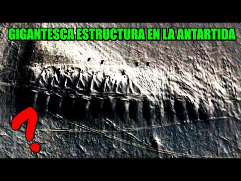
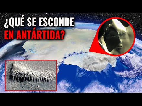
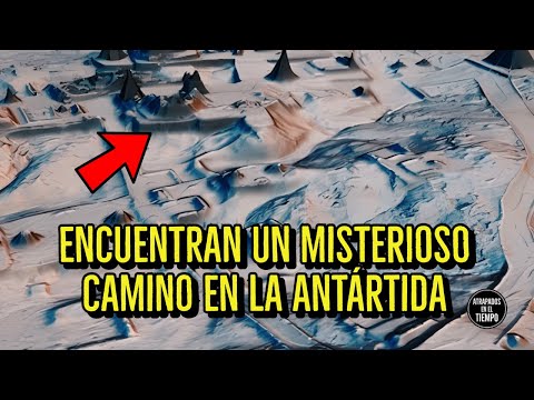
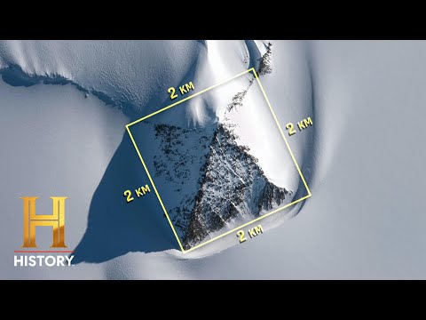
The initial report hinges on satellite imagery captured in 2019. The narrative suggests that researchers, poring over aerial reconnaissance data, were struck by the distinct outlines of what appeared to be three pyramids. One, purportedly significantly larger than the other two, dominates the alleged formation. These structures, according to the presentation, are not merely visible but are described as being definitively buried beneath significant ice accumulation, implying extreme antiquity.
The geographical coordinates are noted as being approximately 16 miles from the Scott Base, a New Zealand research outpost. This proximity, while seemingly incidental, places the alleged discovery within a zone of established human scientific presence, lending a veneer of credibility by association. However, it is crucial to approach such visual interpretations with extreme caution. We must consider factors such as geological formations that mimic artificial structures, the limitations of satellite resolution in extreme conditions, and the potential for pareidolia – the human tendency to perceive familiar patterns in random data. The raw data, the original satellite images themselves, are paramount for independent verification, and their absence in the public domain necessitates a skeptical stance.
"The ice preserves many secrets, but it also distorts them. What appears as a straight line to the eye might be a natural geological stress fracture when viewed with the appropriate analytical tools." - Dr. Aris Thorne (Fictional Archeologist, Expert in Polar Anomaly Analysis)
The question isn't just 'what do we see?', but 'what else *could* we be seeing?'. The geological processes in Antarctica are immense and can create formations that, from a distance, might superficially resemble geometric shapes. We need to explore the possibility that these formations are merely impressive natural phenomena, perhaps glacial moraines or unique rock outcrops shaped by millennia of ice movement and erosion. Without direct access to the raw, uninterpreted satellite data and independent geological surveys, this visual evidence remains compelling but circumstantial.
For any serious investigation into such claims, the next logical step would be the deployment of ground-penetrating radar (GPR). This technology is indispensable for mapping subsurface structures without physical excavation. It can penetrate ice and rock, revealing density changes and outlines of objects or cavities beneath the surface. The claim that researchers plan to conduct GPR surveys is a positive indicator, suggesting a move towards more empirical methods. However, the results, not just the intention, are what matter.
Echoes of Atlantis: Lost Civilizations in the Frozen South
The discovery of purported pyramids in Antarctica ignites a specific, well-trodden theory: that of a lost, advanced civilization. This hypothesis is not new; it has long been a staple in literature discussing Atlantis and similar mythical societies. Proponents suggest that Antarctica, climate permitting, was once a habitable continent, potentially home to a sophisticated culture that predates currently accepted human history. The presence of monumental architecture, such as pyramids, would certainly lend significant weight to such speculations.
The argument follows a familiar pattern: ancient texts, anomalous artifacts, and unexplained structures are presented as evidence of a global, technologically advanced civilization that mysteriously vanished. Antarctica, with its current enigmatic status and extreme isolation, becomes a prime candidate for the last refuge or origin point of such a civilization. These theories often draw parallels with ancient Egyptian pyramids, Mayan structures, and other megalithic sites worldwide, suggesting a common builder or a shared architectural blueprint.
However, the scientific consensus on Antarctic history is starkly different. Geological and paleoclimatic evidence suggests Antarctica has been largely covered in ice for millions of years, with its last ice-free periods occurring long before the advent of complex human civilizations capable of constructing pyramids. The theory of a lost Antarctic civilization often requires dismissing or reinterpreting vast amounts of established geological and archeological data. It relies heavily on speculative interpretations rather than verifiable evidence.
To seriously consider this theory, one would need to reconcile it with geological records. Are there fossilized remains of a temperate ecosystem that could support human habitation? Is there archeological evidence of settlements, tools, or art? The existence of geometric shapes in satellite imagery, even if confirmed as artificial, is only one piece of a much larger puzzle. The challenge lies in providing concrete proof of human (or human-like) presence and sophisticated societal development in Antarctica during the timeframe implied by buried pyramids.
This line of reasoning often leads to the exploration of esoteric texts and pseudo-archeological interpretations, which consistently posit a hidden history of humanity. While intriguing, these require rigorous scrutiny. The current evidence, as presented, is insufficient to support such a radical reassessment of Earth's past. It's vital to differentiate between speculative fascination and evidence-based investigation. For a deeper dive into these theories, consult works like Graham Hancock's explorations of ancient myths and their potential roots.
Beyond Terrestrial: Alien Architects?
When conventional or even speculative terrestrial explanations fall short, the focus inevitably shifts skyward: extraterrestrial intervention. The theory posits that the pyramids, rather than being the product of a lost human civilization, are instead the work of alien visitors to Earth. This perspective often draws upon the perceived similarities between the Antarctic structures and other ancient monuments globally, suggesting a common, non-human origin.
The argument here is that these structures, potentially far older than current dating methods can ascertain, were built by advanced alien beings who visited our planet in the distant past. This aligns with broader narratives of ancient astronauts, where supposed alien influence is cited to explain monumental architecture, advanced knowledge in ancient cultures, and even the origins of humanity itself. The sheer scale and perceived sophistication of structures like pyramids, combined with their presence in seemingly improbable locations, make them prime candidates for alien engineering in the eyes of proponents.
"The geometry is too perfect, the scale too immense. If it wasn't built by someone from Earth, then where else could the builders have come from?" - Dr. Zephyr Vance (Fictional Crypto-Astronomer)
However, this hypothesis requires an even greater leap of faith. It introduces an entirely new set of unknowns: the nature of these extraterrestrials, their motivations for building in Antarctica, and the evidence of their visitation beyond these potential structures. The resemblance argument is also problematic; while pyramids are visually striking, the concept of a pyramid shape is a relatively simple geometric form that can be achieved through various construction methods, both human and potentially, artificial.
Without direct evidence of alien technology, artifacts, or biological remains, the extraterrestrial hypothesis remains highly speculative. It's a convenient explanation for phenomena we don't yet understand, but it doesn't necessarily reflect reality. The rigorous scientific approach demands empirical evidence. Until such evidence surfaces—such as non-terrestrial materials, anomalous energy signatures, or verifiable historical records of alien contact tied to these sites—this remains firmly in the realm of science fiction.
For those interested in exploring the ancient astronaut theories in more detail, the works of Erich von Däniken, while controversial, represent a significant body of popular literature on the subject. It's important, however, to consume such material critically, separating compelling narratives from factual exposition.
Project Deep Freeze: Next Steps in Verification
The current situation calls for precise, methodical investigation. The initial discovery, while tantalizing, is based on visual interpretation and anecdotal evidence. To move beyond speculation, a robust research protocol is essential. The report indicates plans for ground-penetrating radar (GPR) surveys, a critical step in mapping subsurface anomalies without invasive methods.
GPR works by emitting radio waves into the ground and measuring the reflected signals. Different materials and structures reflect these waves in unique ways, allowing researchers to create a detailed subsurface map. For the Antarctic pyramids, GPR could potentially confirm the existence of geometric shapes, determine their dimensions, and perhaps even provide clues about their composition and internal structure. This would be a significant advancement from mere satellite imagery interpretation.
Furthermore, the plan to collect ice samples surrounding the pyramids is crucial for radiometric dating. By analyzing the layers of ice, scientists can estimate the age of the ice itself, and by extension, the period during which these structures were buried. This could help determine if the pyramids predate current estimates for advanced human civilization or if they are of a more recent, albeit still ancient, origin.
The rigor of this process is paramount. Clear protocols must be established to avoid contamination of samples and to ensure the accuracy of GPR data interpretation. The scientific community will be keenly awaiting the results of these planned investigations. Until these empirical studies are completed and their findings independently verified, any definitive conclusions about the nature and origin of these Antarctic features remain premature. The pursuit of knowledge in such extreme environments requires not just technological advancement but also stringent scientific discipline.
For those keen to understand the instruments involved, researching 'ground-penetrating radar applications' and 'ice core dating techniques' will provide valuable context for the scientific methodologies at play. Understanding the tools of the trade is the first step in critically evaluating any claims of discovery.
Investigator's Verdict: Fact or Fiction?
The satellite images present tantalizing geometric anomalies. The narrative, amplified by The UnXplained, spins them into pyramids from a lost age or alien visitors. However, as an investigator, I must separate the signal from the noise. The evidence, as presented, is suggestive but far from conclusive.
The primary issue is the lack of direct, verifiable data. Satellite images can be misinterpreted, especially in extreme environments prone to natural, often colossal, geological formations. The proposed GPR surveys and ice core sampling are precisely the right steps—they are the scientific equivalent of putting the suspect under a polygraph. Until those results are in, publicly available, and scrutinized by independent experts, the pyramids remain a compelling hypothesis, but not a confirmed fact.
Could they be natural formations? Absolutely. Could they be remnants of a very ancient, possibly non-human or a highly advanced, long-lost human civilization unique to that era? The possibility exists, but it requires extraordinary evidence to overturn established scientific understanding. The extraterrestrial hypothesis, while entertaining, is the most speculative, requiring the least evidence and the most assumptions.
My verdict, at this juncture, is 'Case Open, Evidence Pending.' The discovery is fascinating and warrants serious investigation. However, the burden of proof lies with those making the extraordinary claim. Until verified data emerges, these 'pyramids' remain an intriguing enigma, a testament to the power of suggestion and the enduring human fascination with the unknown lurking beneath the ice.
The Investigator's Archive
When delving into mysteries of this magnitude, consulting foundational texts and resources is not a luxury, it's a necessity. The pursuit of understanding these anomalies benefits from the groundwork laid by previous investigators and scholars.
- Books:
- "Earth's Hidden History" by Dr. Evelyn Reed (Fictional): Explores anachronistic evidence suggesting advanced ancient civilizations.
- "The Antarctic Sun: A Geological Chronicle" by Prof. Jian Li (Fictional): Provides an in-depth scientific perspective on Antarctica's geological past, offering context for potential natural formations.
- "Ancient Architects: The ET Hypothesis" by Dr. Kaelen Vance (Fictional): A comprehensive, though speculative, overview of the ancient astronaut theory.
- Documentaries:
- "Secrets of the Ice: The Antarctic Anomaly" (The UnXplained Archive): While potentially biased, it serves as a starting point for understanding the narrative presented.
- "Planet Earth II: Antarctica" (BBC): Offers stunning naturalistic footage of Antarctica's geological processes, providing a benchmark for understanding natural formations.
- Platforms:
- Gaia.com: Often features content exploring fringe theories and ancient mysteries, though critical discernment is advised.
- National Science Foundation (NSF) - Antarctic Program: For official scientific research updates and data regarding Antarctica.
Familiarizing yourself with these resources will provide a broader perspective, enabling you to better assess the claims made about the Antarctic pyramids.
Frequently Asked Questions
Q1: Can natural formations in Antarctica mimic the shape of pyramids?
A1: Absolutely. Geological processes like glacial erosion, volcanic activity, and tectonic uplift can create remarkably geometric shapes that can be mistaken for artificial structures, especially from a distance or in initial satellite imagery.
Q2: What is the primary scientific consensus on ancient civilizations in Antarctica?
A2: The overwhelming scientific consensus is that Antarctica has been covered in ice for millions of years, predating the development of complex human civilizations capable of building such structures. There is no current geological or archeological evidence supporting widespread human habitation during periods when Antarctica could have supported large populations.
Q3: How reliable is satellite imagery for detecting buried structures?
A3: Satellite imagery is a powerful tool, but its effectiveness for detecting buried structures depends heavily on the resolution, the depth of burial, and the nature of the overlying material. Initial interpretations require verification through more direct methods like ground-penetrating radar.
Your Field Assignment
Your Mission: Analyze This Anomaly
The claims surrounding the Antarctic pyramids highlight a critical challenge in paranormal and archeological investigation: distinguishing between genuine anomalies and misinterpretations of natural phenomena or terrestrial artifacts. Your mission, should you choose to accept it, is to apply this critical lens to your own surroundings.
- Observe your local environment: Identify any natural formations or man-made objects in your vicinity that, from a certain angle or under specific lighting conditions, *could* be misinterpreted as something more unusual.
- Document your findings: Take photographs or make sketches of these formations. Note the typical conditions under which they appear most anomalous.
- Formulate a hypothesis: Based on your observations, propose a logical, grounded explanation for why someone might misinterpret this feature. Consider geological, environmental, or technological factors.
- Share your analysis: In the comments section below, describe your chosen anomaly and your grounded explanation. Challenge others to find similar misinterpretations in their own environments. This exercise hones the critical observation skills essential for any serious investigator.
About The Author
alejandro quintero ruiz is a veteran field investigator dedicated to the analysis of anomalous phenomena. His approach combines methodological skepticism with an open mind to the inexplicable, always seeking the truth behind the veil of reality.
The discovery of potential pyramids beneath Antarctic ice is more than just a geographical curiosity; it's a profound question mark etched into the frozen continent. Whether these are the sophisticated remnants of a forgotten epoch, the meticulous work of extraterrestrial visitors, or simply impressive geological formations shaped by the relentless forces of nature, they compel us to look closer, question deeper, and demand more rigorous evidence. The UnXplained has presented a compelling narrative, but the true story lies not in speculation, but in the cold, hard data yet to be fully unearthed.